拉勒米河
拉勒米河(英語:)是北普拉特河的一条支流,长约450千米[5],流经美国的科罗拉多州和怀俄明州。河道以法国捕猎者Jacques La Ramie命名,怀俄明州的拉勒米縣、拉勒米城等多个地名以拉勒米“Laramie”冠名[1]。
| 拉勒米河 Laramie River | |
[[File: Laramie River in Fort Laramie.jpg|256px|none|The Laramie River, as it flows past the site of old Fort Laramie {{|}}]] The Laramie River, as it flows past the site of old Fort Laramie | |
| 名称起源:Named for Jacques La Ramie, French fur trapper [1] | |
| 国家 | 美国 |
|---|---|
| 州 | 科罗拉多州、怀俄明州 |
| 支流 | |
| - 左侧支流 | 北拉勒米河 |
| - 右侧支流 | 楚格沃特河 |
| 城市 | 拉勒米、惠特兰、拉勒米堡 |
| 源头 | Chambers Lake |
| - 位置 | 拉里默爾縣 |
| - 海拔 | 9,192 ft(2,802 m)[2] |
| - 坐标 | 40°36′56″N 105°51′29″W |
| 河口 | 北普拉特河 |
| - 位置 | 戈申縣 |
| - 海拔 | 4,213 ft(1,284 m)[3] |
| - 坐标 | 42°11′59″N 104°31′47″W [3] |
| 长度 | 280 mi(451 km) |
| 流域面积 | 4,564 mi²(11,820 km²)[4] |
| 流量 | 拉勒米堡,距离河口1千米 |
| - 平均流量 | 129 ft³/s(3.7 m³/s)[4] |
| - 最大流量 | 6,260 ft³/s(177.3 m³/s) |
| - 最小流量 | 0 ft³/s(0 m³/s) |
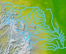 地图中心亮蓝色的为拉勒米河
| |
参见
- 科罗拉多州河流列表
- 怀俄明州河流列表
参考文献
- . Visit Cheyenne. January 1, 2010 [October 12, 2012]. (原始内容存档于2013年8月28日).
- Source elevation derived from Google Earth search using GNIS source coordinates.
- . Geographic Names Information System. United States Geological Survey. October 13, 1978 [October 12, 2012]. (原始内容存档于2021-11-08).
- (PDF). United States Geological Survey. [October 12, 2012]. (原始内容存档 (PDF)于2019-11-12).
- U.S. Geological Survey. National Hydrography Dataset high-resolution flowline data. The National Map (页面存档备份,存于), accessed March 21, 2011
This article is issued from Wikipedia. The text is licensed under Creative Commons - Attribution - Sharealike. Additional terms may apply for the media files.